 << Mapping the senses >>
A crucial theme that has evolved for urban professionals in this network is how to pin down and 'map' the senses. The senses are often ephemeral, difficult to quantify in statistical form however we suggest that they can be mapped and quantified through a mixture of quantitative and qualitative methods. However, it is not just a matter of capturing the senses per se but map their social, political and economic meanings and force.
 i. Individual senses and multi-sensoriality:
Senses can be mapped individually: we can ask which sense predominates and how this offers information about certain social power relations. Or we can think about mapping environments as multi-sensorial spaces (as they are actually experienced by most able bodies) and examine how they interact? Which sense predominates? What is present or absent and why?
> Methods:
Here are a few suggestions that emerged from our workshops
Example 1: London workshop - Mapping the senses
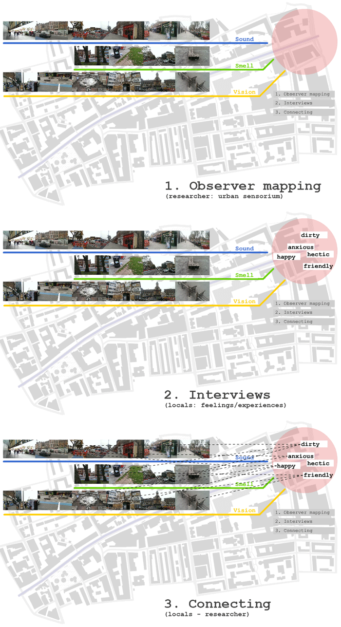
The group chose an observational method. They suggested to create three maps of Whitechapel Road. The first one maps the senses of the observer on the street: What smellscapes can be identified? What can be seen? What do the touchscapes consist of? What can be heard? This is complemented by a map with subjective experiences from people interviewed: What are their feelings about the space? Do they experience a hostile, friendly, oppressive, etc environment? The third step is to create a ‘relationship map’ i.e. asking users of space: why do you experience this space as hostile, friendly or oppressive? The aim of this method is to create ‘places of translation’ bringing together the observational maps of the researcher with the experiences of interviewing people using this space.
Example 2: Cologne workshop - individual senses
> Links to talks/literature:
Here are some talks that illustrate the ways in which sensing can be both highly personal and subjective or social and therefore political.
Joan Subirats (Universitat Autonoma de Barcelona)
Calle Hospital: a political analysis
Lars Frers (University College of Southeast Norway)
Confronting absence: Relation and difference in sensual engagements with the lived city
Raymond Lucas (Senior Lecturer in Architecture and Head of School of Architecture, Manchester University)
Sensory Notations
 ii. Quantifying the senses:
Sensory experiences in the urban realm are a co-creation between the built environment, people’s behaviour and environmental factors. A central question for urban planners is how to quantify sensory perception. The question for urban professionals is how do we evaluate a particular sensescape. We suggest to move away from an aesthetic evaluation of sensescapes to a cultural approach: assessing what is there, what can be sensed, what does this mean in terms of who or what can be sensed and by whom. Such exercise should be done at different times of the day/night and week to capture as many social practices as possible and should be linked to participatory consultation processes (see below).
> Methods:
The benefit of using both quantitative and qualitative methods was highlighted particularly well through the layered mapping method used by one group on Whitechapel Street where three maps were produced:
- Senses of the observer on the street
- Map of subjective experiences gathered through interviews of users of the road
- Creation of a relationship map: i.e. asking users of space: why do you experience this space as hostile, friendly etc and link this to the sensory landscape
Example: London workshop - Mapping the senses
 The group chose an observational method. They suggested to create three maps of Whitechapel Road. The first one maps the senses of the observer on the street: What smellscapes can be identified? What can be seen? What do the touchscapes consist of? What can be heard? This is complemented by a map with subjective experiences from people interviewed: What are their feelings about the space? Do they experience a hostile, friendly, oppressive, etc environment? The third step is to create a ‘relationship map’ i.e. asking users of space: why do you experience this space as hostile, friendly or oppressive? The aim of this method is to create ‘places of translation’ bringing together the observational maps of the researcher with the experiences of interviewing people using this space.
> Links to talks/literature:
Here are examples from our talks illustrating how different professions or academic disciplines go about capturing different sensescapes.
Chris Miele (architectural historian and chartered town planner, Montagu Evans LLP)
Measuring change in a changing city: Understanding London’s expansion
Dr Rainer Katzig (École d’Architecture de Grenoble)
Typical Atmosheres: an approach to facilitate communication on atmospheres
Carolina Vasilikou (University of Kent)
The doors of thermal perception in sensory research


